

Image annotation tool
with AI that labels first.
AI assistants segment, detect and pre-label objects, so annotators only correct them. One canvas covers every shape a vision model trains on, from boxes and polygons to keypoints, cuboids and alpha masks.
AI assistants make the first pass on every image.
Annotators stop tracing outlines point by point. Models segment, detect and pre-label inside the tool, and people spend their time on the cases a model gets wrong.
Box any object and the Smart Tool returns a precise mask that a few clicks correct. Switch between interactive models, including one fine-tuned on your data.
Type a class name and Florence-2 or Grounding DINO labels every match in the image, with no training.
Box one object and every similar object in the image gets its own mask, from bales in a field to products on a shelf.
Run a model you deployed over an image, a selected area or a whole project before anyone starts, and people only fix what it missed.
A model that learns while you label.
Live Training fine-tunes a detection or segmentation model on your project as your team labels it, so every next image arrives pre-labeled and the project ends with a trained model as well as a dataset.
Label the first images
Label as usual. After a few images the model starts to predict, even for classes no public model knows.
Correct instead of draw
Every next image opens with the model’s labels. Fix what it got wrong, and the fix trains the next update.
Draw less, keep the model
Predictions get closer to your final labels with every image, and the checkpoints are ready to deploy.
Every shape a vision model trains on, on one canvas.
Detection, segmentation and pose estimation labels live in one project, so one dataset can feed several models without a second labeling pass.
- Object detection
The workhorse of detection datasets, placed back to back without switching tools.
- Rotated object detection
A box that turns with the object, for cars and ships seen from above or lines of text, and exports to DOTA.
- Instance and semantic segmentation
Touching objects share one border instead of leaving gaps or overlaps, and polygons keep their holes.
- Pixel-accurate segmentation
Brush, eraser and pen give pixel-exact masks, and new strokes can leave the masks already there untouched.
- Lanes, edges and contours
Connected lines for roads, lanes, rivers, wires and the edges of parts.
- Pose estimation
Define a skeleton of named points once, then place it on every person, animal or part, and disable the points that are out of sight.
- 3D boxes in 2D images
A box with depth marks the full volume of a vehicle, parcel or piece of furniture in a single photo, and on fisheye cameras it bends with the lens.
- Image matting
Masks with soft, partly transparent edges for hair, fur, seeds and glass, the training data for background removal.
Multi-camera shots of one scene, labeled as one scene.
Group the images of one moment, from several cameras, angles or spectral bands, and they open side by side. Annotators see an object from every side before they label it.
Views in sync
Pan, zoom and object visibility follow across every view of the group, so nothing is labeled out of context.
One object in every camera
Label groups link the same object across views, so the dataset knows the car on camera 1 is the car on camera 4.
Whole groups in labeling tasks
Labeling tasks and queues hand out groups, not single images, and annotators and reviewers confirm every view on screen at once.
Clean map geometry from aerial and satellite imagery.
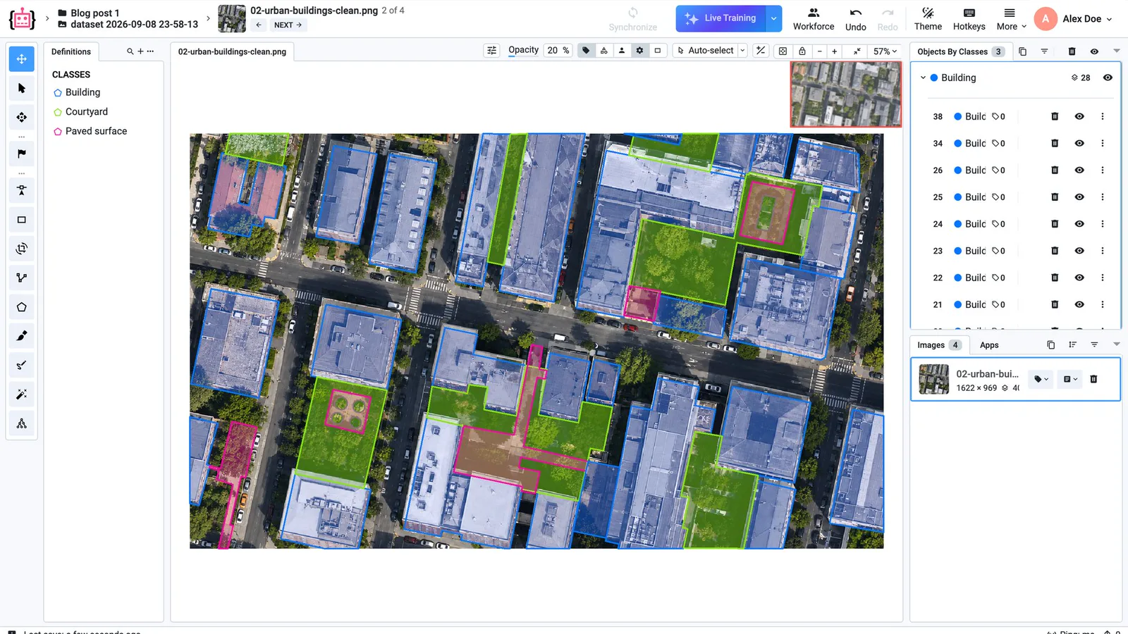
Buildings, parcels and land cover touch each other, and GIS tools reject outlines with gaps, slivers or overlaps. The polygon tools keep them clean as they are drawn.
Shared borders
New polygons snap to the vertices and edges of their neighbours, and moving a shared vertex moves every outline that uses it.
Topology fixed in place
Multipolygons hold one object in several parts with holes. Split a polygon with a line, clip it against its neighbours, or remove every overlap on an image after a preview.
From the map and back
Imagery from the OpenStreetMap pipeline keeps its georeferencing, and finished polygons export to OSM in longitude and latitude.
Fisheye, microscopy and very large images open as they are.
Special imagery gets an interface built for it, so teams don't crop, convert or flatten their data before labeling.
Large, crowded images
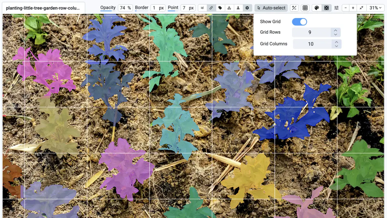
Images with 1000+ objects stay fast, with a minimap and a grid to work through them cell by cell.
Fisheye and panoramic cameras
The camera calibration bends 2D and 3D cuboids and polygons with the lens, on fisheye and cylindrical images alike.
Microscopy and multi-channel data
Fluorescence channels such as DAPI or elevation maps lie over a base image with adjustable opacity, and 16-bit images open with windowing for brightness and contrast.
Here’s why teams trust us.
“A very high product quality.”
BMW Group uses Supervisely to annotate manufacturing images from production lines in their world-wide plants for enhancing quality inspections using deep learning. Supervisely is integrated into the BMW Group AI Platform in order to empower computer vision based AI use cases.
 BMW Group · Manufacturing quality inspection
“Immensely grateful for their pivotal role in our work”
Working with Supervisely has significantly enhanced our capability to develop AI models for lung CT scans. What sets Supervisely apart is its exceptional support team who are really responsive and adapt to our unique needs with a range of apps and helper files.

“Helps us to do data scientist work better and faster”
We use Supervisely since 2019. The key advantage of this tool is that Supervisely provides a complete data treatment pipeline. An important advantage is that a Supervisely instance can be deployed autonomously on a Client infrastructure, and distributed on different servers.

“A valuable part of our computer vision operations”
Supervisely is a valuable part of our computer vision operations, enabling our teams to efficiently work with camera and LiDAR data across sensor fusion projects. We use Supervisely for its extensive feature set and its ability to adapt to our changing requirements.

“Extremely satisfied with Supervisely and would highly recommend it”
The review tools have been invaluable in ensuring the quality and accuracy. The Python SDK has also been incredibly helpful in automating and streamlining our workflow. The support team on Slack has been extremely helpful and responsive.

“Supervisely excels at that and much more”
We’ve been exceedingly impressed with the customer support, addition of new features, and the flexibility of the publicly available SDK/API. The Supervisely team has also been fast to respond to support questions, and has shown a lot of openness when given feedback on potential improvements.

Your team next?
Talk to a computer vision engineer about your data, your models and your infrastructure.
Book a demoFrequently asked questions.
What is the Supervisely image annotation tool?
It is a browser-based toolbox for labeling images for computer vision. It draws bounding boxes, oriented boxes, polygons, masks, polylines, keypoints, 2D cuboids and alpha masks, and its AI assistants segment and pre-label objects, so one project can serve object detection, segmentation, classification and pose estimation. Read the complete guide to the image annotation tool.
Is the image annotation tool free?
Yes. The free Community plan includes the image labeling toolbox and the Smart Tool for 2 members and needs no credit card. Paid plans add members, AI requests and the multi-view, multispectral and high color depth interfaces. Compare plans.
Does the Smart Tool use Segment Anything?
Segment Anything is one of the interactive models the Smart Tool runs, next to others and to models fine-tuned on your own data. Draw a box, correct the mask with a few clicks and save it. Read more about AI-assisted labeling.
Can I import and export COCO, YOLO or Pascal VOC?
Yes. Images come in as JPEG, PNG, TIFF, WebP, HEIC and other formats, with labels in Supervisely JSON, COCO, YOLO, Pascal VOC, Cityscapes, LabelMe or as PNG masks, and the format is detected on upload. Projects export to Supervisely JSON, COCO, YOLO, Pascal VOC, DOTA and PNG masks. See the supported image formats.
Can I label satellite and aerial imagery for GIS?
Yes. Polygons snap to their neighbours so borders are shared, Multipolygons hold objects in several parts, overlaps can be clipped or removed, and imagery prepared with its georeferencing exports to OpenStreetMap format in map coordinates. Read about scalable polygon annotation for geospatial data.